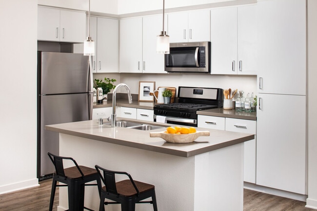
Arbor Pointe Apartments
1 - 2 Beds
$1,745 - $2,095
School
Commute Time (Distance)
Folsom Lake College, El Dorado
Drive: 13 min (7.7 mi)
Property Information
Walkability
Somewhat walkable20 / 100
Transit
Limited public transit30 / 100
Driveability
Exceptionally drivable100 / 100
Bikeability
Somewhat bikeable30 / 100
Shoppers will appreciate 1989 Smith Flat Rd Unit 1989-S proximity to Apple Farm Place, Carson Court, and Broadway Plaza Shopping Center. Apple Farm Place is 1.6 miles away, and Carson Court is within a 35 minute walk.
With a TransitScore of 30, 1989 Smith Flat Rd Unit 1989-S has limited public transit, including 5 transit stops within 44.4 miles. Transit options include Auburn-Conheim and Auburn Amtrak.
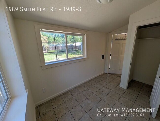
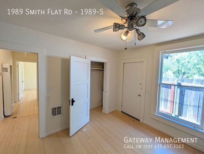
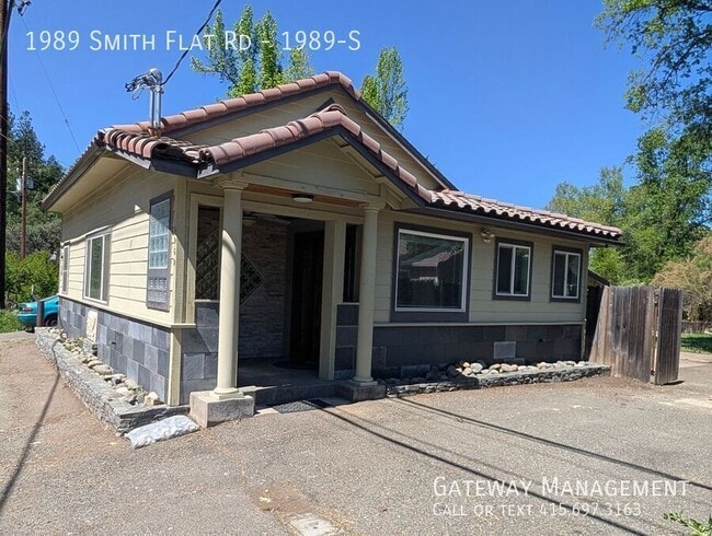
Large three bedroom with a great room connecting large living room and kitchen with a dining room overlooking very large yard
Modern newer tiled large kitchen with lots of counter and cabinet space. Double sink and gas stove. Glass rack,... refrigerator and tiled floor
Full bathroom with stone and granite/ All three bedroom have nice closets but are medium sized or small
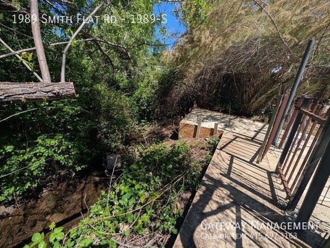
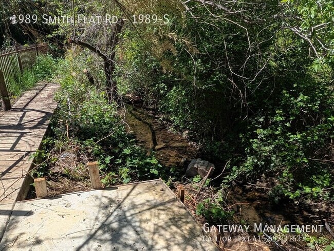
Very large yard features a garden shed, large patio, outdoor sink, additional parking, and a recently landscaped connection to a seasonal creek.
Unit has its own stacked washer/dryer. There is a small basement as well
MORE INFO & SHEDULE A SHOWING
NEIGHBORHOOD: Live in the Sierra Foothills! Where the air is fresher, and history surrounds you. Smith flat is a valley surrounded by Oak forest and fields of grapes on the hillsides. The Starfield Winery.overlooks and exit 49 on highway 50 makes for easy access to el Dorado County
Smith Flat is one of California's oldest communities known in the early days as being a settlement 3 miles from old town Placerville. This Carson Trail stagecoach stop marked the beginning of the ascent or end of the descent from the thousands who traveled to help found the State of California in the 1850s and 1860s. From 1852 on very rich surface diggings were found here in ancient gravel beds. Many tunnels were dug in the surrounding hills to locate more gold. One of the gold rush's richest mines has a preserved opening in the basement of Smith Flat House. This Blue Lead Mine extends all the way to the American River and has made Hangtown Creek which runs through old town Placerville a year round creek.
This area became a prosperous mining camp as well. Ranching and logging kept the Smith’s Flat area going after the mines were shut down. Smith Flat Road became part of California's first state highway which was built in the 1890s connecting Placerville with Lake Tahoe. Old-timers recall when two other nearby locations competed with the Smith Flat House as drinking and dancing establishments.
The Smith Flat House reopened in 2009 as just a healing center based in part on the owner's belief that a large crystal layer, deep below the ground, contained extraordinary healing properties. Today Smith Flat House is again popular as a community gathering space and event center as the exceptional eating establishment closed in early 2026 with the property going on the market
TRANSIT:
There is a local Placerville bus stop next door [More ]
Smith Flat is easily accessed by Exit 49 off Highway 50 and connects to the wineries and Apple Hill [fresh farm to fork] visitor attractions along Carson Road via Jacquier Road. Smith Flat Road and Broadway offer a relatively flat connection to the downtown Placerville bell tower 3 miles downhill . Newtown Road connects to more rural communities of Pleasant Valley and Fair Play. This is also the exit used for the Placerville Airport.
EL DORADO TRAIL is on our block and is a hiking / biking / equestrian trail which is over 30 miles long spanning through the Western Slope of El Dorado County on the former SP Railroad Line. This County trail within the old Michigan/California Railroad right-of-way originally served the old railroad ran from Placerville east through Smith Flat and up to Camino. The largest trailhead is located at Smith Flat with close access to a bridge over Highway 50 that allows trail users access to another 4 miles of trail of ascent into Camino where the forest is transformed into primarily evergreen trees better adapted to snow. A Lincoln Highway marker celebrating Smith Flat Road's role as part of California's first state highway can be found on the front of Smith Flat House.
Water & Sewer
Large three bedroom with a great room connecting large living room and kitchen with a dining room overlooking very large yard
Modern newer tiled large kitchen with lots of counter and cabinet space. Double sink and gas stove. Glass rack, refrigerator and tiled floor
Full bathroom with stone and granite/ All three bedroom have nice closets but are medium sized or small
Very large yard features a garden shed, large patio, outdoor sink, additional parking, and a recently landscaped connection to a seasonal creek.
Unit has its own stacked washer/dryer. There is a small basement as well
MORE INFO & SHEDULE A SHOWING
NEIGHBORHOOD: Live in the Sierra Foothills! Where the air is fresher, and history surrounds you. Smith flat is a valley surrounded by Oak forest and fields of grapes on the hillsides. The Starfield Winery.overlooks and exit 49 on highway 50 makes for easy access to el Dorado County
Smith Flat is one of California's oldest communities known in the early days as being a settlement 3 miles from old town Placerville. This Carson Trail stagecoach stop marked the beginning of the ascent or end of the descent from the thousands who traveled to help found the State of California in the 1850s and 1860s. From 1852 on very rich surface diggings were found here in ancient gravel beds. Many tunnels were dug in the surrounding hills to locate more gold. One of the gold rush's richest mines has a preserved opening in the basement of Smith Flat House. This Blue Lead Mine extends all the way to the American River and has made Hangtown Creek which runs through old town Placerville a year round creek.
This area became a prosperous mining camp as well. Ranching and logging kept the Smith’s Flat area going after the mines were shut down. Smith Flat Road became part of California's first state highway which was built in the 1890s connecting Placerville with Lake Tahoe. Old-timers recall when two other nearby locations competed with the Smith Flat House as drinking and dancing establishments.
The Smith Flat House reopened in 2009 as just a healing center based in part on the owner's belief that a large crystal layer, deep below the ground, contained extraordinary healing properties. Today Smith Flat House is again popular as a community gathering space and event center as the exceptional eating establishment closed in early 2026 with the property going on the market
TRANSIT:
There is a local Placerville bus stop next door [More ]
Smith Flat is easily accessed by Exit 49 off Highway 50 and connects to the wineries and Apple Hill [fresh farm to fork] visitor attractions along Carson Road via Jacquier Road. Smith Flat Road and Broadway offer a relatively flat connection to the downtown Placerville bell tower 3 miles downhill . Newtown Road connects to more rural communities of Pleasant Valley and Fair Play. This is also the exit used for the Placerville Airport.
EL DORADO TRAIL is on our block and is a hiking / biking / equestrian trail which is over 30 miles long spanning through the Western Slope of El Dorado County on the former SP Railroad Line. This County trail within the old Michigan/California Railroad right-of-way originally served the old railroad ran from Placerville east through Smith Flat and up to Camino. The largest trailhead is located at Smith Flat with close access to a bridge over Highway 50 that allows trail users access to another 4 miles of trail of ascent into Camino where the forest is transformed into primarily evergreen trees better adapted to snow. A Lincoln Highway marker celebrating Smith Flat Road's role as part of California's first state highway can be found on the front of Smith Flat House.
Water & Sewer
1989 Smith Flat Rd is located in Placerville, CA in the 95667 zip code.
Within 50 Miles of 1989 Smith Flat Rd Unit 1989-S